• Skip to main content
  • Home
  • About
  • Advertise
  • Archive
    • All
    • 2025
    • 2024
    • 2023
  • CALENDAR
    • All
    • Governmental Entities
    • Homeowners’ Associations
    • Special Events
    • Weekly & Monthly
  • Contact Us
  • E-Edition
  • Sitemap
  • Topics
  • SEARCH
OCN

OCN

Volunteers reporting on community issues in Monument, Palmer Lake, and the surrounding Tri-Lakes area

OCN > 2307 > June Weather Wrap

June Weather Wrap

July 1, 2023

  • A look ahead
  • June 2023 Weather Statistics

By Bill Kappel

June was the second month in a row of well-below normal temperatures and well-above normal rainfall. This was especially the record cold and wet period that was most active during the first three weeks of the month and included several days of severe weather. For the month, temperatures averaged about 4 degrees below normal and precipitation was more than three times the normal amount.

Numerous records were set as well along the Front Range and eastern plains. This included the second wettest period from May 1 through June 17 at the official Denver observational site where records extend back to 1872 and the coldest June 1-17 at that same site since 1872. Daily record rainfall occurred on several days during the month.

All this moisture and daily cloudiness kept temperatures very cool, with our first 80-degree temperatures not occurring until June 18. The last time we hit the 80s in the region was way back on the last day of summer, Sept. 20, 2022. The end of June also marks the end of the snow season. After a slow start we managed to make up a lot of ground from December through April and ended the season quickly with just a small amount of snow recorded in May and none in June.

Overall, we were slightly below normal for the season, just barely breaking above the 100-inch mark. Of course, the abundant moisture in May and June means we are far above normal for the seasonal precipitation having almost reached our yearly total in the first six months.

A cumulonimbus cloud looms large over Black Forest, reflecting the sun as it begins to set in the west at around 8 p.m. on June 21. The Gleneagle community is pictured below the cloud that occurred between two heavy rain storms with large damaging hail on the summer solstice. By 8:30 p.m., the cloud had been replaced with gray skies and electrical activity as the second storm moved in. Photo by Natalie Barszcz.

The first week of the month was wet and cool, with 1-2 inches of rain accumulating. The heaviest rainfall during the period was on the 3rd, when we had cloudy and cold conditions all day. High temperatures only managed to reach the low 50s that afternoon, making our weather feel more like Seattle in the winter than Colorado in the summer.

After a couple days of relatively dry but cool conditions, another week of wet weather moved in. This period included daily thunderstorm activity, with a few days producing hail and flash flooding. The heaviest rain fell on the 7th and the 11th through the 12th. Runoff was exacerbated by the saturated soils as the ground has had no time to dry out.

Extreme shifts in weather are something Coloradans are used to, but the weather changes from June 15 to 16 were even more wild. Early evening on June 15, a double rainbow appeared over the Lake of the Rockies community after a warm shower. The next day, seconds after a severe thunderstorm warning was issued by the National Weather Service in Pueblo, the skies opened up and dumped 2 inches of pea-size hail on the ground, knocking leaves off trees and damaging plants. In one Monument yard, a downspout shaped like a dragon looked like it was vomiting hail. Photo by Michael Weinfeld.

The 14th saw a brief respite from the rainfall, but we were greeted by hazy skies this day as smoke from Canadian wildfires moved into the region. This smoke was quickly cleared out, however, with another round of heavy rainfall and areas of hail on the 15th and 16th.

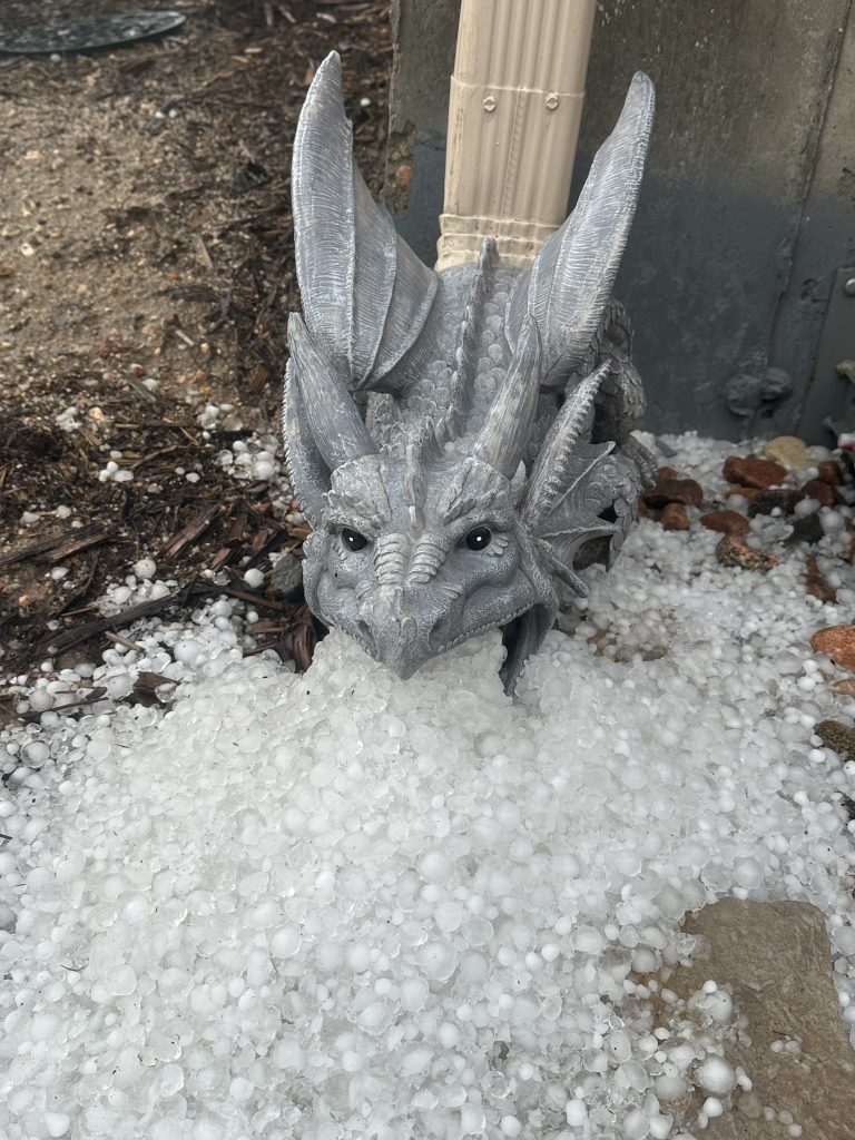
Our first truly summer-like weather finally arrived on the 18th, with sunny skies and temperatures touching 80 degrees. The next afternoon was even warmer, hitting 84 degrees and not a cloud in the sky. After another mild and mostly sunny day on the 21st, more moisture moved back in. This time there was a high amount of instability to combine with the very moist air mass. This combination results in strong to severe thunderstorms on the 22nd and 23rd. Several tornadoes were reported in the region, with the strongest, an EF3 occurring south of Grenada and another near Highlands Ranch. Hail, sometimes large enough to cause damage, occurred both days. On the 22nd the most dramatic aspect was the hail that injured several spectators at Red Rocks Amphitheater. On the 23rd, parts of the Palmer Divide were hit with hail up to 2 inches in diameter, enough to cause dents in cars and damage to roofs.

Finally, a long stretch of relatively dry and quiet weather moved in to end the month. Mainly dry conditions, with sunny skies were the rule from the 24th through the 30th. This allowed the region to begin to dry out a little, just in time for the start of the North American Monsoon season. One benefit of all the moisture is all the plants are happy and everything is green. Now let’s hope our two wettest months of the year (July and August) are well-behaved.

A look ahead

July can be an active weather month around the region, as the Southwest Monsoon season gets going. Afternoon and evening thunderstorms are a common occurrence, and when they tap into higher levels of moisture, flash flooding can result. Hot, stagnant weather can also take hold for a few days at time, with highs hitting the 90s on the warmest days.

June 2023 Weather Statistics

Average High 70.6° (-6.8°); 100-year return frequency value; max 82.5° min 66.3°

Average Low 44.7° (+0.4°); 100-year return frequency value; max 50.7° min 40.2°

Highest Temperature 84°F on the 19th

Lowest Temperature 37°F on the 2nd

Monthly Precipitation 6.58″; (+4.63” 330% above normal); 100-year return frequency value; max 6.94” min 0.15”

Monthly Snowfall: 0.0”; (-0.1” 100% below normal)

Season to Date Snow 105.4”; (-17.1” 14% below normal); (the snow season is from July 1 to June 30)

Season to Date Precip 16.96”; (+5.94” 45% above normal); (the precip season is from Jan 1 to Dec 31)

Heating Degree Days 230 (+135)

Cooling Degree Days 9 (-19)

Bill Kappel is a meteorologist and Tri-Lakes resident. He can be reached at billkappel@ocn.me.

Other Weather articles

  • November Weather Wrap (12/5/2024)
  • October Weather Wrap (11/2/2024)
  • September Weather Wrap (10/5/2024)
  • August Weather Wrap (9/7/2024)
  • July Weather Wrap (8/3/2024)
  • June Weather Wrap (7/6/2024)
  • May Weather Wrap (6/1/2024)
  • April Weather Wrap (5/4/2024)
  • March Weather Wrap (4/6/2024)
  • February Weather Wrap (3/2/2024)
<- Lewis-Palmer Board of Education, June 26 – Board approves budgets for district and Monument Academy
-> Letters to Our Community – Another hidden cost of excessive development

CLICK HERE FOR PODCASTS or OCN UPDATES --- SIGN UP FOR: NEWSLETTERS or ADINFO --- RSS FEEDS: ARTICLES or PODCASTS or COMMENTS
Privacy Policy --- Copyright © 2001–2025. Our Community News, Inc., All rights reserved.

Accessibility Adjustments

Powered by OneTap

Accessibility Commitment for Our Community News, Inc.

At Our Community News, Inc., we are committed to making our digital presence as accessible and inclusive as reasonably possible for all users, including individuals with disabilities. Our goal is to improve the usability of wp.ocn.me and to support a more accessible experience for everyone, regardless of their abilities or the technologies they use.

Our Approach to Accessibility

We aim to align with the Web Content Accessibility Guidelines (WCAG), which define internationally recognized standards for digital accessibility. While full compliance cannot always be guaranteed, we strive to implement improvements where feasible and regularly review accessibility-related aspects of our website. Accessibility is an ongoing process, and we are committed to improving the experience over time as technologies, standards, and user needs evolve.

Accessibility Features

To support accessibility, wp.ocn.me may utilize tools such as the OneTap accessibility toolbar. This interface provides users with a range of helpful features, including:
  • Adjustable text size and contrast settings
  • Dark mode for those who prefer that presentation
  • Highlighting of links and text for better visibility
  • Quick launch via keyboard shortcut: Alt + . (Windows) or ⌘ + . (Mac)
Please note the following:
  • The availability and effectiveness of these features depend on the website's configuration and ongoing maintenance.
  • While we strive to ensure accessibility, we cannot guarantee that every part of wp.ocn.me will be fully accessible at all times. Some content may be provided by third parties or affected by technical constraints beyond our immediate control.

Accessibility Tools

We implemented an accessibility icon on the upper right of the screen. It is a figure with arms and legs outstretched in a dark gray circle. Clicking on the accessibility icon will open a toolbar with many options to adjust the text and the screen. We also implemented a dark mode tool, which appears to the left of the accessibility icon as a smaller circle that initially is half-gray and half yellow indicating the screen will adjust to the system’s dark mode setting. Clicking on the dark mode tool will switch it to a sun icon meaning light mode. Clicking again will switch it to a moon icon meaning dark mode. Clicking again brings it back to half-and-half. If the accessibility tools are obstructing something you want to view, you can open the accessibility toolbar and select "Hide toolbar." Leave the setting at the default of “Only for this session” and click Hide Toolbar. That will reveal a small dark circle containing a minus sign. If you click on the minus sign, the dark mode tool will be removed and the minus will change to a plus. Click on the plus sign to bring back the accessibility icon and the dark mode tool.

Feedback and Contact

We welcome your feedback. If you experience any accessibility barriers or have suggestions for improvement, please contact us: Email: johnheiser@ocn.me We are committed to reviewing all inquiries and aim to respond within 3–5 business days. If you require assistance accessing any part of this website, we are happy to provide support through alternative channels upon request. Last updated: November 3, 2025
How long do you want to hide the toolbar?
Hide Toolbar Duration
Select your accessibility profile
Vision Impaired Mode
Enhances website's visuals
Seizure Safe Profile
Clear flashes & reduces color
ADHD Friendly Mode
Focused browsing, distraction-free
Blindness Mode
Reduces distractions, improves focus
Epilepsy Safe Mode
Dims colors and stops blinking
Content Modules
Font Size

Default

Line Height

Default

Color Modules
Orientation Modules

Keep up-to-date on Tri-Lakes area news and upcoming events with our free OCN App!

Check It OutAlready InstalledNo, Thanks

Subscribe to our newsletter for the latest Tri-Lakes news and website updates!

Sign Up NowAlready SubscribedNo, Thanks